-
You are here:
- Homepage » Mauritius
Mauritius Country Guide
Explore Mauritius in Africa
Mauritius with the capital city Port Louis is located in Africa (Southern Africa, island in the Indian Ocean). It covers some 2,040 square kilometres (almost 11 times the size of Washington, DC) with 1,260,000 citizens.
The topography includes small coastal plain rising to discontinuous mountains encircling central plateau. The average density of population is approximately 618 per km². The notable climate conditions in Mauritius can be described as tropical, modified by southeast trade winds with warm, dry winter (May to November) and hot, wet, humid summer (November to May). Possible natural disasters include cyclones (November to April) or almost completely surrounded by reefs that may pose maritime hazards.
To reach someone in Mauritius dial +230 prior to a number. There are 379,100 installed telephones. And there are 1,087,000 registered mobile phones. The cellular networks commonly support frequencies of 900 MHz. Websites registered in this country end with the top level domain ".mu". If you want to bring electric equipment on your trip (e.g. laptop power supply), note the local power outlet of 230V - 50Hz.
About the flag and history of Mauritius
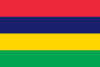
Four equal horizontal bands of red (top), blue, yellow, and green; red represents self-determination and independence, blue the Indian Ocean surrounding the island, yellow has been interpreted as the new light of independence, golden sunshine, or the bright future, and green can symbolize either agriculture or the lush vegetation of the island.
Although known to Arab and Malay sailors as early as the 10th century, Mauritius was first explored by the Portuguese in the 16th century and subsequently settled by the Dutch - who named it in honor of Prince Maurits van NASSAU - in the 17th century. The French assumed control in 1715, developing the island into an important naval base overseeing Indian Ocean trade, and establishing a plantation economy of sugar cane. The British captured the island in 1810, during the Napoleonic Wars. Mauritius remained a strategically important British naval base, and later an air station, playing an important role during World War II for anti-submarine and convoy operations, as well as the collection of signals intelligence. Independence from the UK was attained in 1968. A stable democracy with regular free elections and a positive human rights record, the country has attracted considerable foreign investment and has earned one of Africa's highest per capita incomes.
Geography Quick-Facts
| Summary | Continent: Africa Neighbours: Capital: Port Louis |
| Size | 2,040 square kilometers (km² or sqkm) or 787 square miles (mi² or sqmi) almost 11 times the size of Washington, DC |
| Population | 1,260,000 |
| Currency | Name Rupee, Currency Code:MUR |
| Country Top Level Domain (cTLD) | .mu |
| Telephone Country Prefix | +230 |
| Mobile Phone Connections | 1,087,000 |
| Landline Phone Connections | 379,100 |
Country Position in World Rankings
Information about single country attributes and how these compare against the rest of the world. The information below is compiled with data from 2013. As such, it may differ a bit to the Information above in the text (which is from 2010).
Geography
| Value name | Value | World Rank |
|---|---|---|
| Area | 2,040 (sq km) | 181 |
People and Society
| Value name | Value | World Rank |
|---|---|---|
| Population | 1,322,238 | 155 |
| Population growth rate | 0.68 (%) | 142 |
| Birth rate | 13.62 (births/1,000 population) | 147 |
| Death rate | 6.79 (deaths/1,000 population) | 139 |
| Maternal mortality rate | 60.00 (deaths/100,000 live births) | 99 |
| Infant mortality rate | 10.89 (deaths/1,000 live births) | 138 |
| Life expectancy at birth | 74.94 (years) | 101 |
| Total fertility rate | 1.78 (children born/woman) | 157 |
| Health expenditures | 6.00 (% of GDP) | 108 |
| HIV/AIDS - adult prevalence rate | 1.00 (%) | 49 |
| HIV/AIDS - people living with HIV/AIDS | 8,800 | 102 |
| HIV/AIDS - deaths | 500 | 85 |
| Obesity - adult prevalence rate | 18.50 (%) | 105 |
| Education expenditures | 3.70 (% of GDP) | 122 |
| Unemployment, youth ages 15-24 | 21.70 (%) | 52 |
Economy
| Value name | Value | World Rank |
|---|---|---|
| GDP (purchasing power parity) | 20,530,000,000 | 130 |
| GDP - real growth rate | 3.30 (%) | 101 |
| GDP - per capita (PPP) | 15,800 | 87 |
| Labor force | 617,800 | 155 |
| Unemployment rate | 8.00 (%) | 94 |
| Distribution of family income - Gini index | 39.00 | 68 |
| Investment (gross fixed) | 23.30 (% of GDP) | 62 |
| Taxes and other revenues | 21.10 (% of GDP) | 155 |
| Budget surplus (+) or deficit (-) | -4.30 (% of GDP) | 145 |
| Public debt | 61.80 (% of GDP) | 43 |
| Inflation rate (consumer prices) | 4.70 (%) | 134 |
| Commercial bank prime lending rate | 8.92 (%) | 103 |
| Stock of narrow money | 2,293,000,000 | 123 |
| Stock of broad money | 26,170,000,000 | 80 |
| Stock of domestic credit | 11,750,000,000 | 93 |
| Market value of publicly traded shares | 6,506,000,000 | 80 |
| Industrial production growth rate | 3.30 (%) | 83 |
| Current account balance | -1,433,000,000 | 124 |
| Exports | 2,631,000,000 | 136 |
| Imports | 5,111,000,000 | 128 |
| Reserves of foreign exchange and gold | 2,848,000,000 | 110 |
| Debt - external | 5,768,000,000 | 109 |
Energy
| Value name | Value | World Rank |
|---|---|---|
| Electricity - production | 2,889,000,000 (kWh) | 129 |
| Electricity - consumption | 2,687,000,000 (kWh) | 135 |
| Electricity - installed generating capacity | 885,200 (kW) | 126 |
| Electricity - from fossil fuels | 75.20 (% of total installed capacity) | 100 |
| Electricity - from hydroelectric plants | 6.70 (% of total installed capacity) | 122 |
| Electricity - from other renewable sources | 18.10 (% of total installed capacity) | 7 |
| Refined petroleum products - consumption | 24,710 (bbl/day) | 124 |
| Refined petroleum products - imports | 22,750 (bbl/day) | 102 |
| Carbon dioxide emissions from consumption of energy | 4,545,000 (Mt) | 127 |
Communications
| Value name | Value | World Rank |
|---|---|---|
| Telephones - main lines in use | 374,600 | 107 |
| Telephones - mobile cellular | 1,294,000 | 150 |
| Internet hosts | 51,139 | 95 |
| Internet users | 290,000 | 132 |
Transportation
| Value name | Value | World Rank |
|---|---|---|
| Airports | 5 | 183 |
| Roadways | 2,066 (km) | 173 |
| Merchant marine | 4 | 132 |
Military
| Value name | Value | World Rank |
|---|---|---|
| Military expenditures | 0.10 (% of GDP) | 171 |
Data based on CIA facts book 2010 & 2013, wikipedia, national statistical offices and their census releases
List of current world heritage sites
| Name | Since |
|---|---|
| Aapravasi Ghat In the district of Port Louis, lies the 1,640 m2 site where the modern indentured labour diaspora began. In 1834, the British Government selected the island of Mauritius to be the first site for what it called ‘the great experiment’ in the use of ‘fr ... | 2006 |
| Le Morne Cultural Landscape Le Morne Cultural Landscape, a rugged mountain that juts into the Indian Ocean in the southwest of Mauritius was used as a shelter by runaway slaves, maroons, through the 18th and early years of the 19th centuries. Protected by the mountain’s isolate ... | 2008 |