-
You are here:
- Homepage » Sudan
Sudan Country Guide
Explore Sudan in Africa
The landscape offers generally flat, featureless plain with mountains in far south, northeast, and west and desert dominates the north. The average density of population is approximately 16 per km². The notable climate conditions in Sudan can be described as tropical in south with arid desert in north and rainy season varies by region (April to November). Potential threats by nature are dust storms and periodic persistent droughts.
To reach someone in Sudan dial +249 prior to a number. There are 370,400 installed telephones. And there are 15,340,000 registered mobile phones. The cellular networks commonly support frequencies of 900/1800/3G MHz. Websites registered in this country end with the top level domain ".sd". If you want to bring electric equipment on your trip (e.g. laptop power supply), note the local power outlet of 230V - 50Hz.
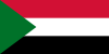
About the flag and history of Sudan
Three equal horizontal bands of red (top), white, and black with a green isosceles triangle based on the hoist side; colors and design based on the Arab Revolt flag of World War I, but the meanings of the colors are expressed as follows: red signifies the struggle for freedom, white is the color of peace, light, and love, black represents Sudan itself (in Arabic 'Sudan' means black), green is the color of Islam, agriculture, and prosperity.
Military regimes favoring Islamic-oriented governments have dominated national politics since independence from the UK in 1956. Sudan was embroiled in two prolonged civil wars during most of the remainder of the 20th century. These conflicts were rooted in northern economic, political, and social domination of largely non-Muslim, non-Arab southern Sudanese. The first civil war ended in 1972 but broke out again in 1983. The second war and famine-related effects resulted in more than four million people displaced and, according to rebel estimates, more than two million deaths over a period of two decades. Peace talks gained momentum in 2002-04 with the signing of several accords. The final North/South Comprehensive Peace Agreement (CPA), signed in January 2005, granted the southern rebels autonomy for six years followed by a referendum on independence for Southern Sudan. The referendum was held in January 2011 and indicated overwhelming support for independence. South Sudan became independent on 9 July 2011. Since southern independence Sudan has been combating rebels from the Sudan People's Liberation Movement-North (SPLM-N) in Southern Kordofan and Blue Nile states. A separate conflict, which broke out in the western region of Darfur in 2003, has displaced nearly two million people and caused an estimated 200,000 to 400,000 deaths. The UN took command of the Darfur peacekeeping operation from the African Union in December 2007. Peacekeeping troops have struggled to stabilize the situation, which has become increasingly regional in scope and has brought instability to eastern Chad. Sudan also has faced large refugee influxes from neighboring countries primarily Ethiopia and Chad. Armed conflict, poor transport infrastructure, and lack of government support have chronically obstructed the provision of humanitarian assistance to affected populations.
Geography Quick-Facts
| Summary | Continent: Africa Neighbours: Chad, Eritrea, Ethiopia, Libya, Kenya, Central African Republic, Democratic Republic of the Congo, Uganda, Egypt Capital: Khartoum |
| Size | 2,505,810 square kilometers (km² or sqkm) or 967,498 square miles (mi² or sqmi) slightly more than one-quarter the size of the US |
| Population | 40,218,000 |
| Currency | Name Dinar, Currency Code:SDD |
| Country Top Level Domain (cTLD) | .sd |
| Telephone Country Prefix | +249 |
| Mobile Phone Connections | 15,340,000 |
| Landline Phone Connections | 370,400 |
Country Position in World Rankings
Information about single country attributes and how these compare against the rest of the world. The information below is compiled with data from 2013. As such, it may differ a bit to the Information above in the text (which is from 2010).
Geography
| Value name | Value | World Rank |
|---|---|---|
| Area | 1,861,484 (sq km) | 16 |
People and Society
| Value name | Value | World Rank |
|---|---|---|
| Population | 34,847,910 | 35 |
| Population growth rate | 1.83 (%) | 64 |
| Birth rate | 30.84 (births/1,000 population) | 41 |
| Death rate | 8.09 (deaths/1,000 population) | 93 |
| Net migration rate | -4.44 (migrant(s)/1,000 population) | 189 |
| Maternal mortality rate | 730.00 (deaths/100,000 live births) | 8 |
| Infant mortality rate | 54.23 (deaths/1,000 live births) | 35 |
| Life expectancy at birth | 62.95 (years) | 185 |
| Total fertility rate | 4.05 (children born/woman) | 39 |
| Health expenditures | 6.30 (% of GDP) | 101 |
| HIV/AIDS - adult prevalence rate | 1.10 (%) | 45 |
| HIV/AIDS - people living with HIV/AIDS | 260,000 | 22 |
| HIV/AIDS - deaths | 12,000 | 23 |
| Obesity - adult prevalence rate | 6.00 (%) | 150 |
| Children under the age of 5 years underweight | 31.70 (%) | 12 |
Economy
| Value name | Value | World Rank |
|---|---|---|
| GDP (purchasing power parity) | 86,670,000,000 | 78 |
| GDP - real growth rate | -4.40 (%) | 216 |
| GDP - per capita (PPP) | 2,600 | 182 |
| Labor force | 11,920,000 | 45 |
| Unemployment rate | 20.00 (%) | 161 |
| Investment (gross fixed) | 26.00 (% of GDP) | 43 |
| Taxes and other revenues | 7.50 (% of GDP) | 213 |
| Budget surplus (+) or deficit (-) | -9.30 (% of GDP) | 204 |
| Public debt | 89.30 (% of GDP) | 18 |
| Inflation rate (consumer prices) | 31.50 (%) | 221 |
| Stock of narrow money | 7,847,000,000 | 85 |
| Stock of broad money | 12,830,000,000 | 96 |
| Stock of domestic credit | 10,970,000,000 | 95 |
| Industrial production growth rate | 3.50 (%) | 80 |
| Current account balance | -3,575,000,000 | 153 |
| Exports | 4,548,000,000 | 118 |
| Imports | 6,645,000,000 | 113 |
| Reserves of foreign exchange and gold | 297,900,000 | 155 |
| Debt - external | 39,700,000,000 | 66 |
Energy
| Value name | Value | World Rank |
|---|---|---|
| Electricity - production | 6,509,000,000 (kWh) | 108 |
| Electricity - consumption | 4,611,000,000 (kWh) | 118 |
| Electricity - installed generating capacity | 2,338,000 (kW) | 97 |
| Electricity - from fossil fuels | 30.70 (% of total installed capacity) | 179 |
| Electricity - from hydroelectric plants | 66.30 (% of total installed capacity) | 26 |
| Electricity - from other renewable sources | 3.00 (% of total installed capacity) | 48 |
| Crude oil - production | 120,000 (bbl/day) | 48 |
| Crude oil - exports | 370,700 (bbl/day) | 23 |
| Crude oil - proved reserves | 5,000,000,000 (bbl) | 25 |
| Refined petroleum products - production | 85,890 (bbl/day) | 78 |
| Refined petroleum products - consumption | 95,450 (bbl/day) | 81 |
| Refined petroleum products - exports | 14,950 (bbl/day) | 82 |
| Refined petroleum products - imports | 24,820 (bbl/day) | 94 |
| Natural gas - proved reserves | 84,950,000,000 (cu m) | 60 |
| Carbon dioxide emissions from consumption of energy | 13,790,000 (Mt) | 92 |
Communications
| Value name | Value | World Rank |
|---|---|---|
| Telephones - main lines in use | 483,600 | 100 |
| Telephones - mobile cellular | 25,056,000 | 42 |
| Internet hosts | 99 | 211 |
| Internet users | 4,200,000 | 56 |
Transportation
| Value name | Value | World Rank |
|---|---|---|
| Airports | 72 | 74 |
| Railways | 5,978 (km) | 30 |
| Roadways | 11,900 (km) | 131 |
| Waterways | 4,068 (km) | 25 |
| Merchant marine | 2 | 145 |
Military
| Value name | Value | World Rank |
|---|---|---|
| Military expenditures | 4.20 (% of GDP) | 24 |
Data based on CIA facts book 2010 & 2013, wikipedia, national statistical offices and their census releases
List of current world heritage sites
| Name | Since |
|---|---|
| Archaeological Sites of the Island of Meroe The Archaeological Sites of the Island of Meroe, a semi-desert landscape between the Nile and Atbara rivers, was the heartland of the Kingdom of Kush, a major power from the 8th century B.C. to the 4th century A.D. The property consists of the royal ... | 2011 |
| Gebel Barkal and the Sites of the Napatan Region These five archaeological sites, stretching over more than 60 km in the Nile valley, are testimony to the Napatan (900 to 270 BC) and Meroitic (270 BC to 350 AD) cultures, of the second kingdom of Kush. Tombs, with and without pyramids, temples, livi ... | 2003 |