-
You are here:
- Homepage » Suriname
Suriname Country Guide
Explore Suriname in South America
Suriname with the capital city Paramaribo is located in South America (Northern South America, bordering the North Atlantic Ocean). It covers some 163,270 square kilometres (slightly larger than Georgia) with 475,000 citizens.
The landscape offers mostly rolling hills with narrow coastal plain with swamps. The average density of population is approximately 3 per km². The notable climate conditions in Suriname can be described as tropical with moderated by trade winds. Potential threats by nature are NA.
To reach someone in Suriname dial +597 prior to a number. There are 83,700 installed telephones. And there are 763,900 registered mobile phones. The cellular networks commonly support frequencies of 900/1800 MHz. Websites registered in this country end with the top level domain ".sr". If you want to bring electric equipment on your trip (e.g. laptop power supply), note the local power outlet of 127V - 60Hz.
About the flag and history of Suriname
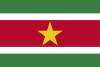
Five horizontal bands of green (top, double width), white, red (quadruple width), white, and green (double width); a large, yellow, five-pointed star is centered in the red band; red stands for progress and love; green symbolizes hope and fertility; white signifies peace, justice, and freedom; the star represents the unity of all ethnic groups; from its yellow light the nation draws strength to bear sacrifices patiently while working toward a golden future.
First explored by the Spaniards in the 16th century and then settled by the English in the mid-17th century, Suriname became a Dutch colony in 1667. With the abolition of African slavery in 1863, workers were brought in from India and Java. Independence from the Netherlands was granted in 1975. Five years later the civilian government was replaced by a military regime that soon declared a socialist republic. It continued to exert control through a succession of nominally civilian administrations until 1987, when international pressure finally forced a democratic election. In 1990, the military overthrew the civilian leadership, but a democratically elected government - a four-party coalition - returned to power in 1991. The coalition expanded to eight parties in 2005 and ruled until August 2010, when voters returned former military leader Desire BOUTERSE and his opposition coalition to power.
Geography Quick-Facts
| Summary | Continent: South America Neighbours: Guyana, Brazil, French Guiana Capital: Paramaribo |
| Size | 163,270 square kilometers (km² or sqkm) or 63,038 square miles (mi² or sqmi) slightly larger than Georgia |
| Population | 475,000 |
| Currency | Name Dollar, Currency Code:SRD |
| Country Top Level Domain (cTLD) | .sr |
| Telephone Country Prefix | +597 |
| Mobile Phone Connections | 763,900 |
| Landline Phone Connections | 83,700 |
Country Position in World Rankings
Information about single country attributes and how these compare against the rest of the world. The information below is compiled with data from 2013. As such, it may differ a bit to the Information above in the text (which is from 2010).
Geography
| Value name | Value | World Rank |
|---|---|---|
| Area | 163,820 (sq km) | 92 |
People and Society
| Value name | Value | World Rank |
|---|---|---|
| Population | 566,846 | 170 |
| Population growth rate | 1.15 (%) | 102 |
| Birth rate | 17.10 (births/1,000 population) | 115 |
| Death rate | 6.15 (deaths/1,000 population) | 159 |
| Net migration rate | 0.57 (migrant(s)/1,000 population) | 64 |
| Maternal mortality rate | 130.00 (deaths/100,000 live births) | 63 |
| Infant mortality rate | 27.99 (deaths/1,000 live births) | 69 |
| Life expectancy at birth | 71.41 (years) | 145 |
| Total fertility rate | 2.04 (children born/woman) | 123 |
| Health expenditures | 7.00 (% of GDP) | 82 |
| HIV/AIDS - adult prevalence rate | 1.00 (%) | 46 |
| HIV/AIDS - people living with HIV/AIDS | 3,700 | 123 |
| HIV/AIDS - deaths | 200 | 104 |
| Obesity - adult prevalence rate | 25.10 (%) | 60 |
| Children under the age of 5 years underweight | 7.50 (%) | 74 |
| Unemployment, youth ages 15-24 | 21.50 (%) | 53 |
Economy
| Value name | Value | World Rank |
|---|---|---|
| GDP (purchasing power parity) | 6,874,000,000 | 162 |
| GDP - real growth rate | 4.50 (%) | 72 |
| GDP - per capita (PPP) | 12,600 | 103 |
| Labor force | 165,600 | 176 |
| Unemployment rate | 9.00 (%) | 103 |
| Taxes and other revenues | 17.40 (% of GDP) | 180 |
| Budget surplus (+) or deficit (-) | -2.40 (% of GDP) | 90 |
| Inflation rate (consumer prices) | 6.00 (%) | 158 |
| Commercial bank prime lending rate | 11.75 (%) | 69 |
| Stock of narrow money | 1,132,000,000 | 145 |
| Stock of broad money | 2,300,000,000 | 148 |
| Stock of domestic credit | 1,286,000,000 | 151 |
| Industrial production growth rate | 6.50 (%) | 46 |
| Current account balance | 577,200,000 | 43 |
| Exports | 2,927,000,000 | 131 |
| Imports | 1,838,000,000 | 166 |
| Reserves of foreign exchange and gold | 1,048,000,000 | 135 |
| Debt - external | 504,300,000 | 171 |
Energy
| Value name | Value | World Rank |
|---|---|---|
| Electricity - production | 1,603,000,000 (kWh) | 141 |
| Electricity - consumption | 1,463,000,000 (kWh) | 146 |
| Electricity - installed generating capacity | 389,000 (kW) | 146 |
| Electricity - from fossil fuels | 51.40 (% of total installed capacity) | 155 |
| Electricity - from hydroelectric plants | 48.60 (% of total installed capacity) | 43 |
| Crude oil - production | 16,000 (bbl/day) | 76 |
| Crude oil - proved reserves | 72,000,000 (bbl) | 79 |
| Refined petroleum products - production | 7,407 (bbl/day) | 108 |
| Refined petroleum products - consumption | 14,100 (bbl/day) | 147 |
| Refined petroleum products - exports | 1,058 (bbl/day) | 109 |
| Refined petroleum products - imports | 6,430 (bbl/day) | 145 |
| Carbon dioxide emissions from consumption of energy | 2,343,000 (Mt) | 149 |
Communications
| Value name | Value | World Rank |
|---|---|---|
| Telephones - main lines in use | 85,500 | 150 |
| Telephones - mobile cellular | 947,000 | 156 |
| Internet hosts | 188 | 202 |
| Internet users | 163,000 | 146 |
Transportation
| Value name | Value | World Rank |
|---|---|---|
| Airports | 47 | 93 |
| Roadways | 4,304 (km) | 154 |
| Waterways | 1,200 (km) | 59 |
Military
| Value name | Value | World Rank |
|---|---|---|
| Military expenditures | 1.20 (% of GDP) | 116 |
Data based on CIA facts book 2010 & 2013, wikipedia, national statistical offices and their census releases
List of current world heritage sites
| Name | Since |
|---|---|
| Central Suriname Nature Reserve The Central Suriname Nature Reserve comprises 1.6 million ha of primary tropical forest of west-central Suriname. It protects the upper watershed of the Coppename River and the headwaters of the Lucie, Oost, Zuid, Saramaccz, and Gran Rio rivers and c ... | 2000 |
| Historic Inner City of Paramaribo Paramaribo is a former Dutch colonial town from the 17th and 18th centuries planted on the northern coast of tropical South America. The original and highly characteristic street plan of the historic centre remains intact. Its buildings illustrate th ... | 2002 |