-
You are here:
- Homepage » Togo
Togo Country Guide
Explore Togo in Africa
The topography includes gently rolling savanna in north with central hills, southern plateau and low coastal plain with extensive lagoons and marshes. The average density of population is approximately 103 per km². The notable climate conditions in Togo can be described as tropical with hot, humid in south and semiarid in north. Possible natural disasters include hot, dry harmattan wind can reduce visibility in north during winter or periodic droughts.
To reach someone in Togo dial +228 prior to a number. There are 178,700 installed telephones. And there are 2,187,000 registered mobile phones. The cellular networks commonly support frequencies of 900 MHz. Websites registered in this country end with the top level domain ".tg". If you want to bring electric equipment on your trip (e.g. laptop power supply), note the local power outlet of 220V - 50Hz.
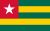
About the flag and history of Togo
Five equal horizontal bands of green (top and bottom) alternating with yellow; a white five-pointed star on a red square is in the upper hoist-side corner; the five horizontal stripes stand for the five different regions of the country; the red square is meant to express the loyalty and patriotism of the people; green symbolizes hope, fertility, and agriculture; yellow represents mineral wealth and faith that hard work and strength will bring prosperity; the star symbolizes life, purity, peace, dignity, and Togo's independence note: uses the popular Pan-African colors of Ethiopia.
French Togoland became Togo in 1960. Gen. Gnassingbe EYADEMA, installed as military ruler in 1967, ruled Togo with a heavy hand for almost four decades. Despite the facade of multi-party elections instituted in the early 1990s, the government was largely dominated by President EYADEMA, whose Rally of the Togolese People (RPT) party has maintained power almost continually since 1967 and maintains a majority of seats in today's legislature. Upon EYADEMA''s death in February 2005, the military installed the president''s son, Faure GNASSINGBE, and then engineered his formal election two months later. Democratic gains since then allowed Togo to hold its first relatively free and fair legislative elections in October 2007. After years of political unrest and condemnation from international organizations for human rights abuses, Togo is finally being re-welcomed into the international community. In January 2012, Togo assumed a nonpermanent seat on the UN Security Council for the 2012-13 term.
Geography Quick-Facts
| Summary | Continent: Africa Neighbours: Benin, Ghana, Burkina Faso Capital: Lomé |
| Size | 56,785 square kilometers (km² or sqkm) or 21,924 square miles (mi² or sqmi) slightly smaller than West Virginia |
| Population | 5,858,000 |
| Currency | Name Franc, Currency Code:XOF |
| Country Top Level Domain (cTLD) | .tg |
| Telephone Country Prefix | +228 |
| Mobile Phone Connections | 2,187,000 |
| Landline Phone Connections | 178,700 |
Country Position in World Rankings
Information about single country attributes and how these compare against the rest of the world. The information below is compiled with data from 2013. As such, it may differ a bit to the Information above in the text (which is from 2010).
Geography
| Value name | Value | World Rank |
|---|---|---|
| Area | 56,785 (sq km) | 126 |
People and Society
| Value name | Value | World Rank |
|---|---|---|
| Population | 7,154,237 | 100 |
| Population growth rate | 2.73 (%) | 20 |
| Birth rate | 34.90 (births/1,000 population) | 26 |
| Death rate | 7.60 (deaths/1,000 population) | 111 |
| Maternal mortality rate | 300.00 (deaths/100,000 live births) | 39 |
| Infant mortality rate | 48.28 (deaths/1,000 live births) | 43 |
| Life expectancy at birth | 63.62 (years) | 178 |
| Total fertility rate | 4.58 (children born/woman) | 28 |
| Health expenditures | 7.70 (% of GDP) | 68 |
| HIV/AIDS - adult prevalence rate | 3.20 (%) | 22 |
| HIV/AIDS - people living with HIV/AIDS | 120,000 | 38 |
| HIV/AIDS - deaths | 7,700 | 28 |
| Obesity - adult prevalence rate | 4.30 (%) | 169 |
| Children under the age of 5 years underweight | 20.50 (%) | 32 |
| Education expenditures | 4.60 (% of GDP) | 91 |
Economy
| Value name | Value | World Rank |
|---|---|---|
| GDP (purchasing power parity) | 7,024,000,000 | 161 |
| GDP - real growth rate | 5.00 (%) | 65 |
| GDP - per capita (PPP) | 1,100 | 213 |
| Labor force | 2,595,000 | 111 |
| Investment (gross fixed) | 25.40 (% of GDP) | 46 |
| Taxes and other revenues | 19.80 (% of GDP) | 165 |
| Budget surplus (+) or deficit (-) | -3.90 (% of GDP) | 135 |
| Inflation rate (consumer prices) | 2.80 (%) | 65 |
| Central bank discount rate | 4.25 (%) | 86 |
| Stock of narrow money | 954,500,000 | 150 |
| Stock of broad money | 1,534,000,000 | 158 |
| Stock of domestic credit | 1,119,000,000 | 154 |
| Industrial production growth rate | 2.50 (%) | 106 |
| Current account balance | -418,400,000 | 91 |
| Exports | 893,800,000 | 160 |
| Imports | 1,492,000,000 | 170 |
| Reserves of foreign exchange and gold | 678,000,000 | 146 |
Energy
| Value name | Value | World Rank |
|---|---|---|
| Electricity - production | 123,000,000 (kWh) | 191 |
| Electricity - consumption | 651,000,000 (kWh) | 162 |
| Electricity - imports | 683,000,000 (kWh) | 70 |
| Electricity - installed generating capacity | 85,000 (kW) | 172 |
| Electricity - from fossil fuels | 21.20 (% of total installed capacity) | 189 |
| Electricity - from hydroelectric plants | 78.80 (% of total installed capacity) | 16 |
| Refined petroleum products - consumption | 28,670 (bbl/day) | 119 |
| Refined petroleum products - imports | 6,829 (bbl/day) | 143 |
| Carbon dioxide emissions from consumption of energy | 3,166,000 (Mt) | 139 |
Communications
| Value name | Value | World Rank |
|---|---|---|
| Telephones - main lines in use | 240,000 | 125 |
| Telephones - mobile cellular | 3,105,000 | 126 |
| Internet hosts | 1,168 | 170 |
| Internet users | 356,300 | 123 |
Transportation
| Value name | Value | World Rank |
|---|---|---|
| Airports | 8 | 162 |
| Railways | 568 (km) | 110 |
| Roadways | 7,520 (km) | 146 |
| Waterways | 50 (km) | 103 |
| Merchant marine | 61 | 65 |
Military
| Value name | Value | World Rank |
|---|---|---|
| Military expenditures | 1.90 (% of GDP) | 74 |
Data based on CIA facts book 2010 & 2013, wikipedia, national statistical offices and their census releases
List of current world heritage sites
| Name | Since |
|---|---|
| Koutammakou, the Land of the Batammariba The Koutammakou landscape in north-eastern Togo, which extends into neighbouring Benin, is home to the Batammariba whose remarkable mud tower-houses (Takienta) have come to be seen as a symbol of Togo. In this landscape, nature is strongly associated ... | 2004 |