
Delve into Etel in France
Etel in the region of Bretagne with its 2,068 residents is located in France - some 268 mi or ( 432 km ) West of Paris , the country's capital .
Local time in Etel is now 01:10 PM (Monday) . The local timezone is named " Europe/Paris " with a UTC offset of 1 hours. Depending on your mobility, these larger destinations might be interesting for you: London, Bristol, Vieux-Passage, Vannes, and Saint-Nazaire. While being here, you might want to check out London . We discovered some clip posted online . Scroll down to see the most favourite one or select the video collection in the navigation. Are you curious about the possible sightseeing spots and facts in Etel ? We have collected some references on our attractions page.
Videos
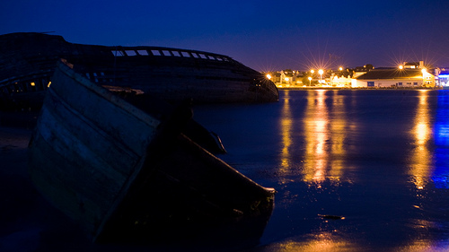
Der Schiffsfriedhof von Etel
Bretonische Thunfischfänger haben den letzten Ankerplatz angelaufen - Der Schiffsfriedhof von Etel ..
Vac's Plouhinec
Paysages sur les côtes du Morbihan ..
http://team-breizh-patator.skyrock.com/ remix trip
remix trip et défis ..
Waiting for the sea
On a summers day on a beach in France, play in the sand and sea ..
Videos provided by Youtube are under the copyright of their owners.
Interesting facts about this location
Kerzerho
Kerzerho lies approximately 8 km northwest of Carnac in the Erdeven commune and in the region of Brittany, France.
Located at 47.63 -3.15 (Lat./Long.); Less than 5 km away
Mane Braz
Mane Braz is a Megalithic tomb located 2 km southeast of Erdeven, Brittany, France. The site comprises four side chambers and two small dolmens. It is built into a hill and appears to be the remains of a tumulus.
Located at 47.64 -3.13 (Lat./Long.); Less than 6 km away
Carnac stones
The Carnac stones are an exceptionally dense collection of megalithic sites around the French village of Carnac, in Brittany, consisting of alignments, dolmens, tumuli and single menhirs. The more than 3,000 prehistoric standing stones were hewn from local rock and erected by the pre-Celtic people of Brittany, and are the largest such collection in the world. Most of the stones are within the Breton village of Carnac, but some to the east are within La Trinité-sur-Mer.
Located at 47.61 -3.06 (Lat./Long.); Less than 12 km away
Téviec
Téviec or Théviec is an island situated to the west of the isthmus of the peninsula of Quiberon, near Saint-Pierre-Quiberon in Brittany, France. The island is an important archaeological site due to its occupation during the Mesolithic period. Many archaeological finds have been made dating back to over 6,700 years before the present day, including the remains of over 20 people.
Located at 47.55 -3.17 (Lat./Long.); Less than 12 km away
Blavet
For the French flautist, see Michel Blavet The Blavet river flows from central Brittany and enters the Atlantic Ocean on the south coast near Lorient. The river is canalized for most of its length and is navigable for smaller craft. It is part of Brittany's canal system and became more important when the western half of that system got cut off by the construction of Lake Guerlédan's hydroelectric power dam.
Located at 47.71 -3.37 (Lat./Long.); Less than 14 km away
Pictures
Related Locations
Information of geographic nature is based on public data provided by geonames.org, CIA world facts book, Unesco, DBpedia and wikipedia. Weather is based on NOAA GFS.