-
You are here:
- Homepage »
- France »
- Franche-Comte » Plancher-les-Mines

Plancher-les-Mines Destination Guide
Discover Plancher-les-Mines in France
Plancher-les-Mines in the region of Franche-Comté with its 1,090 habitants is a place located in France - some 216 mi or ( 347 km ) East of Paris , the country's capital .
Local time in Plancher-les-Mines is now 11:37 PM (Saturday) . The local timezone is named " Europe/Paris " with a UTC offset of 1 hours. Depending on your mobility, these larger cities might be interesting for you: Berne, Basel, Brussels, Valdoie, and Strasbourg. When in this area, you might want to check out Berne . We discovered some clip posted online . Scroll down to see the most favourite one or select the video collection in the navigation. Are you looking for some initial hints on what might be interesting in Plancher-les-Mines ? We have collected some references on our attractions page.
Videos
EASY JOB IN FRANCE ...col de Bussang (Bussang Pass)
Bussang Pass between the Vosges and Alsace in the east of France i had to deliver near Mulhouse ...this road is only allowed to the trucks over 3.5 tons who must load or unload in the 2 departements o ..
NOTRE DAME DU HAUT DE RONCHAMP-1.avi
mi-cha-el.livejournal.com ..
Wiz Khalifa - Black and Yellow - Live @ Eurockéennes de Belfort 2012
Concert du rappeur Wiz Khalifa sur la scène "Green Room" pendant le festival des Eurockéennes de Belfort, qui interprète Black and Yellow. Concert of the rapper Wiz Khalifa on the stage "Green Room" d ..
BMW 1200 GS France, Ballon d'Alsace, D465
Pics from a TL 1000 during a trip from Methven, Scotland to St Tropez .......... ..
Videos provided by Youtube are under the copyright of their owners.
Interesting facts about this location
Lac de Malsaucy
Lac de Malsaucy is a lake in the Territoire de Belfort, Franche-Comté, France. The lake with a surface of is 0.64 km² shared by three communes: Evette-Salbert, Lachapelle-sous-Chaux and Sermamagny. The rock festival Eurockéennes is held each July on a peninsula on the lake.
Located at 47.69 6.80 (Lat./Long.); Less than 9 km away
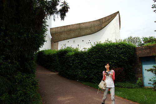
Notre Dame du Haut
The chapel of Notre Dame du Haut in Ronchamp (French: Chapelle Notre-Dame-du-Haut de Ronchamp), completed in 1954, is one of the finest examples of the architecture of Franco-Swiss architect Le Corbusier and one of the most important examples of twentieth-century religious architecture.
Located at 47.70 6.62 (Lat./Long.); Less than 11 km away
Fort du Salbert
Fort du Salbert, also known as Fort Lefebvre, was built between 1874 and 1877. It was named after General François Joseph Lefebvre. It forms part of the Séré de Rivières system fortifications in the fortified region of Belfort in northeastern France. It is located at the summit of Salbert hill to the northwest of Belfort. During the early years of the Cold War it briefly served as an air defense coordination center.
Located at 47.66 6.82 (Lat./Long.); Less than 13 km away
Canton of Le Thillot
The Canton of Le Thillot is a French administrative and electoral grouping of communes in the Vosges département of eastern France and in the region of Lorraine. Positioned within the Arrondissement of Épinal, the canton has its administrative centre at Le Thillot.
Located at 47.88 6.77 (Lat./Long.); Less than 13 km away
Château d'Étobon
The Château d'Étobon is a ruined castle in the commune of Étobon in the Haute-Saône département of France, 6 km from the town of Héricourt. The ruins stand on a hill dominating the village of Étobon. Its position and its considerable construction works contributed to its strength. It is 167 m above the village, and measures 220 m by 60 m. Burned and destroyed by the Duke of Furstemberg in 1519, it fell into ruin.
Located at 47.65 6.68 (Lat./Long.); Less than 13 km away
Pictures
Historical Weather
Related Locations
Information of geographic nature is based on public data provided by geonames.org, CIA world facts book, Unesco, DBpedia and wikipedia. Weather is based on NOAA GFS.