-
You are here:
- Homepage »
- France »
- Pays de la Loire » Charce-Saint-Ellier-sur-Aubance

Charce-Saint-Ellier-sur-Aubance Destination Guide
Discover Charce-Saint-Ellier-sur-Aubance in France
Charce-Saint-Ellier-sur-Aubance in the region of Pays de la Loire with its 662 habitants is a town located in France - some 164 mi or ( 264 km ) South-West of Paris , the country's capital .
Local time in Charce-Saint-Ellier-sur-Aubance is now 05:11 PM (Monday) . The local timezone is named " Europe/Paris " with a UTC offset of 1 hours. Depending on your flexibility, these larger cities might be interesting for you: Vauchretien, Trelaze, Tours, Thouarce, and Saint-Sulpice. When in this area, you might want to check out Vauchretien . We found some clip posted online . Scroll down to see the most favourite one or select the video collection in the navigation. Are you looking for some initial hints on what might be interesting in Charce-Saint-Ellier-sur-Aubance ? We have collected some references on our attractions page.
Videos
Monsabert.m4v
Partie de water polo dans la piscine du Yelloh Village du Parc de Monsabert ..
Crâne dans la Loire - courrierdelouest.fr
Il retrouve un crâne dans la Loire - www.courrierdelouest.fr ..
L'HISTOIRE MERVEILLEUSE DE A & M.wmv
Avec G. Bizet, les Rois Mages se préparent A effectuer une longue marche Pour gagner la Liberté et la Paix Avec A & M comme symboles de fin d'année... Cath CR JOYEUX NOEL A TOUS ET BONNES FÊTES DE FIN ..
Brissac 2009
..
Videos provided by Youtube are under the copyright of their owners.
Interesting facts about this location
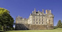
Château de Brissac
The Château de Brissac is a noble mansion in the commune of Brissac-Quincé, in the département of Maine-et-Loire, France. It was originally built as a castle by the Counts of Anjou in the 11th century. After the victory over the English by Philip II of France, he gave the property to Guillaume des Roches. (the castle got the name Brissac from one of its owners The Duke of Brissac) In the 15th century, the structure was rebuilt by Pierre de Brézé, a wealthy chief minister to King Charles VII.
Located at 47.35 -0.45 (Lat./Long.); Less than 3 km away
Saint-Maur-sur-Loire
Saint-Maur-sur-Loire is a village of western France in the département of Maine-et-Loire on the Loire River, part of the commune of Le Thoureil, about 15 m. below Saumur.
Located at 47.39 -0.28 (Lat./Long.); Less than 10 km away
Jean-Bouin Stadium, Angers
Jean-Bouin Stadium is a football stadium in Angers, France. It is only used for football matches and is the home ground of Angers SCO. The stadium holds 17,835 people, a capacity which was reached in 2010 with the reconstruction of the Coubertin stand.
Located at 47.46 -0.53 (Lat./Long.); Less than 14 km away
Anjou
Anjou is a former county (in the sense of being ruled by a count, from c. 880), duchy (1360) and province centred on the city of Angers in the lower Loire Valley of western France. Its traditional Latin name was Andegavia. Anjou was united with the English Crown from 1151-1199, when Henry II, and, in turn, his (third) son Richard the Lionheart, inherited the county, and thus themselves became Counts of Anjou. At its peak, the Angevin Empire then spread from Ulster to the Pyrenees.
Located at 47.47 -0.55 (Lat./Long.); Less than 16 km away
Château de Montgeoffroy
The Château de Montgeoffroy is an 18th century manor house located in the commune of Mazé, France. In 1676, Érasme de Contades acquired the property. In 1772, the Marshal Louis Georges Érasme de Contades, governor of Alsace, decided to rebuild the château as a retirement home. He called on the Parisian architect Jean-Benoît-Vincent Barré, who worked with the local architect Simier.
Located at 47.47 -0.28 (Lat./Long.); Less than 16 km away
Pictures
Related Locations
Information of geographic nature is based on public data provided by geonames.org, CIA world facts book, Unesco, DBpedia and wikipedia. Weather is based on NOAA GFS.

