-
You are here:
- Homepage »
- Mexico »
- Baja California » Merida

Merida Destination Guide
Explore Merida in Mexico
Merida in the region of Baja California is a town in Mexico - some 1,337 mi or ( 2152 km ) North-West of Mexico City , the country's capital city .
Current time in Merida is now 03:17 AM (Thursday) . The local timezone is named " America/Tijuana " with a UTC offset of -7 hours. Depending on the availability of means of transportation, these more prominent locations might be interesting for you: El Riito, Borquez, Rancho San Isidro, Linch, and Rancho Grande. Since you are here already, make sure to check out El Riito . We saw some video on the web . Scroll down to see the most favourite one or select the video collection in the navigation. Where to go and what to see in Merida ? We have collected some references on our attractions page.
Videos
Cultivo del algodon en Cuervos.
cuervos.com.mx ..
First Christmas In The Desert
This is how we spent our first Christmas when we moved from Chicago to the Sonoran Desert ..
Cuervo Time-laps
Viernes 13 2012 Timelaps ..
Videos provided by Youtube are under the copyright of their owners.
Interesting facts about this location
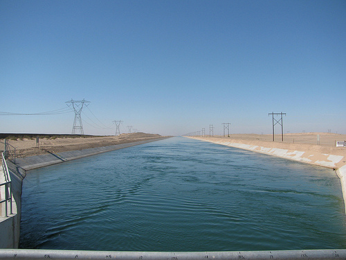
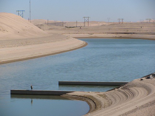
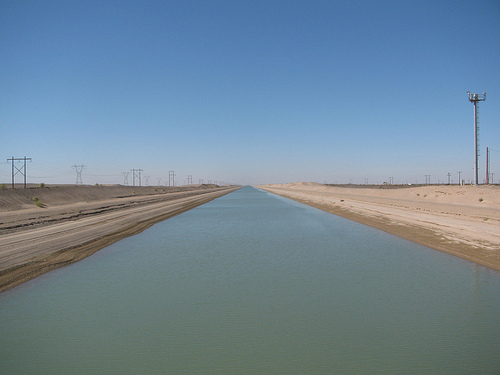
All-American Canal Bridge
The All-American Canal Bridge is a bridge that carries Interstate 8 over the All-American Canal, a canal that supplies water from the Colorado River to the agricultural areas of the Imperial Valley. The bridge is located in Imperial County, California, east of El Centro. The current eastbound was originally built in 1939 as U.S. Highway 80; in 1969, the bridge was widened to include freeway shoulders, and the bridge to serve westbound traffic was built as well.
Located at 32.71 -114.95 (Lat./Long.); Less than 6 km away
Gadsden, Arizona
Gadsden is a census-designated place (CDP) in Yuma County, Arizona, United States. The population was 953 at the 2000 census. It is part of the Yuma Metropolitan Statistical Area.
Located at 32.56 -114.78 (Lat./Long.); Less than 17 km away
Felicity, California
Felicity is an unincorporated community in Imperial County, California, referred to as the "Center of the World". It lies at an elevation of 285 feet (87 m). Founded on May 11, 1986, the community was named after a town mentioned in Jacques-André Istel's book Coe the Good Dragon and inspired by his wife, Felicia. It is accessible from Interstate 8 in the far southeast of the state, just west of Yuma, Arizona.
Located at 32.75 -114.76 (Lat./Long.); Less than 18 km away
Dunes, California
Dunes is an unincorporated community in Imperial County, California. It is located on the Southern Pacific Railroad 3.5 miles southeast of Ogilby, at an elevation of 331 feet (101 m).
Located at 32.78 -114.80 (Lat./Long.); Less than 18 km away
Morelos Dam
After a 1944 United States Mexico Treaty the Morelos Dam was built in 1950 across the Colorado River. It is located about 1 mile below the junction of the California border and the Colorado River between the town of Los Algodones, Baja California, in northwestern Mexico and Yuma County, Arizona in the southwestern United States. The eastern half the dam lies inside United States territory; but Mexico is responsible for all maintenance.
Located at 32.71 -114.73 (Lat./Long.); Less than 18 km away
Pictures

Related Locations
Information of geographic nature is based on public data provided by geonames.org, CIA world facts book, Unesco, DBpedia and wikipedia. Weather is based on NOAA GFS.