
Delve into Ramos Arizpe in Mexico
Ramos Arizpe in the region of Coahuila with its 38,258 residents is located in Mexico - some 439 mi or ( 706 km ) North of Mexico City , the country's capital .
Local time in Ramos Arizpe is now 10:55 AM (Sunday) . The local timezone is named " America/Monterrey " with a UTC offset of -6 hours. Depending on your mobility, these larger destinations might be interesting for you: Ciudad Victoria, San Juan, San Luis Potosí, Saltillo, and Rancho de Pena. While being here, you might want to check out Ciudad Victoria . We discovered some clip posted online . Scroll down to see the most favourite one or select the video collection in the navigation. Are you curious about the possible sightseeing spots and facts in Ramos Arizpe ? We have collected some references on our attractions page.
Videos
KCSM 3445, 3442, 4521, 4539, 4678, 4720, 4716
Waiting....... ..
KCS 4112, 4116, 3930, 4009
*HIGH-QUALITY* el "kansas special" GKCMX-05, al fin asta ke gravo una SD70mac,las otras salen sobrando :P, la SD70ACe gris se ve chido lastima ke no venia de lider... ..
KCSM 4533, CSX 7772, 8080 y UP 9364
que combinacion de maquinas!!!! nice locomotives :D.... ..
KCSM 4655 4667 y 4722
Este tren de kcsm se dirige al norte lleva 3 es44 la cual solo una biene en la eskema del bicentenario de mexico en total son 3 makinas con eskema conmemorativa y un cabus con eskema del centenario de ..
Videos provided by Youtube are under the copyright of their owners.
Interesting facts about this location
Ramos Arizpe
Ramos Arizpe is a city and seat of the surrounding municipality of the same name in the Mexican state of Coahuila. Ramos Arizpe is located 11 km from the state capital of Saltillo. It is part of the Saltillo metropolitan area. The city reported a population of 48,228 in the 2005 census; the municipality had a population of 56,708. Its area is 5,306.6 km² (2,048.9 sq mi).
Located at 25.55 -100.97 (Lat./Long.); Less than 0 km away
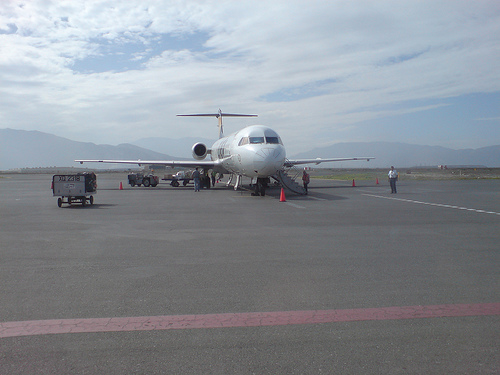
Plan de Guadalupe International Airport
Plan de Guadalupe International Airport (Spanish: Aeropuerto Internacional Plan de Guadalupe) is an airport located at Ramos Arizpe in the state of Coahuila in Mexico. It handles national and international air traffic from the metropolitan area of Saltillo and Ramos Arizpe. This airport receives few flights a day due to its proximity to Monterrey's General Mariano Escobedo International Airport and Del Norte International Airport.
Located at 25.55 -100.93 (Lat./Long.); Less than 4 km away
Estadio de Béisbol Francisco I. Madero
Estadio de Béisbol Francisco I. Madero is a stadium in Saltillo, Mexico. It is primarily used for baseball and is the home field of the Saraperos de Saltillo. It holds 16,000 people, and features a video screen measuring 14 meters high by 22 meters wide (46 feet high by 72 feet wide). The stadium is named after Coahuila native Francisco I. Madero who served as President of Mexico from 1911 to 1913. The stadium was renovated in 1999, and again in 2011.
Located at 25.43 -100.98 (Lat./Long.); Less than 13 km away
Battle of Buena Vista
The Battle of Buena Vista (23 February 1847), also known as the Battle of Angostura, saw the United States (U.S. ) Army use artillery to repulse the much larger Mexican army in the Mexican-American War. Buena Vista, a village of the state of Coahuila, is seven miles (12 km) south of Saltillo, in northern Mexico.
Located at 25.34 -101.05 (Lat./Long.); Less than 25 km away
Pictures

Related Locations
Information of geographic nature is based on public data provided by geonames.org, CIA world facts book, Unesco, DBpedia and wikipedia. Weather is based on NOAA GFS.