
Explore Oxtotipac in Mexico
Oxtotipac in the region of México is a town in Mexico - some 28 mi or ( 45 km ) North-East of Mexico City , the country's capital city .
Current time in Oxtotipac is now 12:11 AM (Monday) . The local timezone is named " America/Mexico City " with a UTC offset of -6 hours. Depending on the availability of means of transportation, these more prominent locations might be interesting for you: Xometla, Toluca, Texcoco, San Salvador Atenco, and San Juan Teotihuacan. Since you are here already, make sure to check out Xometla . We encountered some video on the web . Scroll down to see the most favourite one or select the video collection in the navigation. Where to go and what to see in Oxtotipac ? We have collected some references on our attractions page.
Videos
Teotihuacan (HD 1080p)
Teotihuacan is an enormous archaeological site in the Basin of Mexico, containing some of the largest pyramidal structures built in the pre-Columbian Americas. Apart from the pyramidal structures, Teo ..
Episode 15: Teotihucan
A tour of the Aztec city of Teotihucan. ..
Tren Ejecutivo Kansas City Southern de México
Transmisión desde el recorrido Polanco-Teotihuacán. Entrevista con José Zozaya, presidente de la empresa ferroviaria Kansas City Southern de México. ..
7mo Festival de Globos Aerostaticos Teotihuacan Amanecer 2011
En el Globopuerto Volare, cada año al llegar la primavera se reunen los entusiastas de los Globos Aerostaticos para vuelos libres y exhibiciones. Este video muestra solamente el espectáculo nocturno d ..
Videos provided by Youtube are under the copyright of their owners.
Interesting facts about this location
Otumba de Gómez Farías
Otumba or Otumba de Gómez Farías is a town and municipality located in the northeast of the State of Mexico, just northeast of Mexico City. Historically, this area is best known as the site of the Battle of Otumba and as an important crossroads during the colonial period where incoming viceroys ceremoniously were handed power by their predecessors. Today, it is a rural municipality undergoing changes as urbanization arrives here from the Mexico City area.
Located at 19.70 -98.75 (Lat./Long.); Less than 5 km away
Otumba, State of Mexico
Otumba is a municipio (municipality) of State of Mexico in Mexico. The municipal seat and largest settlement is Otumba de Gómez Farías. The municipality of Otumba has a land area of some 143.42 square kilometres, and a population recorded in the intermedial 2005 census, the Conteo de Población y Vivienda, of 29,873.
Located at 19.70 -98.75 (Lat./Long.); Less than 5 km away
Temple of the Feathered Serpent, Teotihuacan
The Temple of the Feathered Serpent is the modern-day name for the third largest pyramid at Teotihuacan, a pre-Columbian site in central Mexico. This structure is notable partly due to the discovery in the 1980s of more than a hundred possibly-sacrificial victims found buried beneath the structure. The burials, like the structure, are dated to some time between 150 and 200 CE. The pyramid takes its name from representations of the Mesoamerican "feathered serpent" deity which covered its sides.
Located at 19.68 -98.85 (Lat./Long.); Less than 7 km away
Teotihuacan
Teotihuacan, also written Teotihuacán, is an enormous archaeological site in the Basin of Mexico, 30 miles northeast of Mexico City, containing some of the largest Mesoamerican pyramids built in the pre-Columbian Americas. The name means "where man met the gods. " Apart from the pyramids, Teotihuacan is also known for its large residential complexes, the Avenue of the Dead, and numerous colorful, well-preserved murals.
Located at 19.69 -98.84 (Lat./Long.); Less than 7 km away
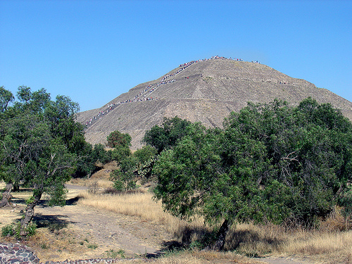
Pyramid of the Sun
The Pyramid of the Sun is the largest building in Teotihuacan and one of the largest in Mesoamerica. Found along the Avenue of the Dead, in between the Pyramid of the Moon and the Ciudadela, and in the shadow of the massive mountain Cerro Gordo, the pyramid is part of a large complex in the heart of the city.
Located at 19.69 -98.84 (Lat./Long.); Less than 7 km away
Pictures
Related Locations
Information of geographic nature is based on public data provided by geonames.org, CIA world facts book, Unesco, DBpedia and wikipedia. Weather is based on NOAA GFS.