
Explore Cuilapan de Guerrero in Mexico
Cuilapan de Guerrero in the region of Oaxaca with its 10,782 inhabitants is a town in Mexico - some 228 mi or ( 368 km ) South-East of Mexico City , the country's capital city .
Current time in Cuilapan de Guerrero is now 03:54 AM (Friday) . The local timezone is named " America/Mexico City " with a UTC offset of -6 hours. Depending on the availability of means of transportation, these more prominent locations might be interesting for you: Zimatlan de Alvarez, Trinidad de Zaachila, Tlalixtac de Cabrera, Santa Maria del Tule, and Teitipac. Since you are here already, make sure to check out Zimatlan de Alvarez . We encountered some video on the web . Scroll down to see the most favourite one or select the video collection in the navigation. Where to go and what to see in Cuilapan de Guerrero ? We have collected some references on our attractions page.
Videos
OAX Oaxaca Mexico Landing Embraer
Landing Embraer at OAX ..
Danza de Pluma (Espacio) - Villa de Zaachila, Oaxaca (Esto es... Oaxaca)
www.viveoaxaca.org Grupo de danza de pluma Buin Ni Rya de la Villa de Zaachila interpretando espacio en el atrio de la iglesia de la comunidad. ..
Chocosol Chocolate: From Beans to Bar
I followed Micheal Sacco, a chocolatier, through the remote jungles in Oaxaca Mexico to find out the true story of chocolate. It was an amazing trip, where I learned not only the story of Micheal's am ..
Aterrizaje en Oaxaca
Aterrizaje en el aeropuerto de la ciudad de Oaxaca en un Cessna Caravan de Aerotucán (Mayo 22, 2010) Visita Huatulco, Puerto Escondido y Tuxtla Gutiérrez por Aerotucán www.aerotucan.com.mx ..
Videos provided by Youtube are under the copyright of their owners.
Interesting facts about this location
Santa Cruz Xoxocotlán
Santa Cruz Xoxocotlán is a small city and municipality located 5 km from the state capital of Oaxaca in the south of Mexico. It is part of the Centro District in the Valles Centrales region. The name comes from the Nahuatl word “xocotl” which means “sour or sweet and sour fruit” with the duplicative “xo” to indicate “very. ” The meaning of the entire phrase means “among the very sour fruits. ” The Mixtec name for the area was Nuunitatnohoyoo which mean “land of the moon-faced flowers.
Located at 17.02 -96.73 (Lat./Long.); Less than 4 km away
Xoxocotlán International Airport
Xoxocotlán International Airport Is an international airport located at Oaxaca, Oaxaca, Mexico. The airport has only one terminal that handles domestic and international air traffic.
Located at 17.00 -96.73 (Lat./Long.); Less than 4 km away
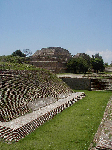
Monte Albán
Monte Albán is a large pre-Columbian archaeological site in the Santa Cruz Xoxocotlán Municipality in the southern Mexican state of Oaxaca (17.043° N, 96.767°W). The site is located on a low mountainous range rising above the plain in the central section of the Valley of Oaxaca where the latter's northern Etla, eastern Tlacolula, and southern Zimatlán & Ocotlán branches meet. The present-day state capital Oaxaca City is located approximately 9 km east of Monte Albán.
Located at 17.04 -96.77 (Lat./Long.); Less than 5 km away
Valley of Oaxaca
The Valley of Oaxaca is a geographic region located within the modern day State of Oaxaca in southern Mexico. The valley, which is located within the Sierra Madre Mountains, is shaped like a distorted and almost upside-down “Y,” with each of its arms bearing specific names: the northwestern Etla arm, the central southern Valle Grande, and the Tlacolula arm to the east.
Located at 17.05 -96.77 (Lat./Long.); Less than 5 km away
San Raymundo Jalpan
San Raymundo Jalpan is a town and municipality in Oaxaca in south-western Mexico. The municipality covers an area of km². It is part of the Centro District in the Valles Centrales region. As of 2005, the municipality had a total population of .
Located at 16.97 -96.73 (Lat./Long.); Less than 5 km away
Pictures


Related Locations
Information of geographic nature is based on public data provided by geonames.org, CIA world facts book, Unesco, DBpedia and wikipedia. Weather is based on NOAA GFS.