
Discover Texcal in Mexico
Texcal in the region of Puebla is a town located in Mexico - some 104 mi or ( 168 km ) East of Mexico City , the country's capital .
Local time in Texcal is now 09:22 PM (Tuesday) . The local timezone is named " America/Mexico City " with a UTC offset of -6 hours. Depending on your flexibility, these larger cities might be interesting for you: Tlamanaca, Santiago Zautla, San Nicolas Temextla, San Miguel Tenextatiloyan, and Puebla. When in this area, you might want to check out Tlamanaca . We found some clip posted online . Scroll down to see the most favourite one or select the video collection in the navigation. Are you looking for some initial hints on what might be interesting in Texcal ? We have collected some references on our attractions page.
Videos
Ocotepec puebla
..
Ocotepec Pueabla
I created this video at www.youtube.com ..
cuyoaco puebla 2012
..
Videos provided by Youtube are under the copyright of their owners.
Interesting facts about this location
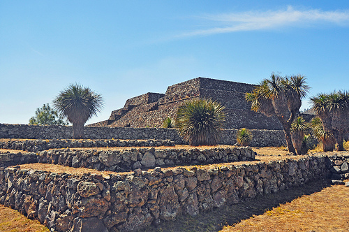
Cantona (Mesoamerican site)
Cantona, (La casa del sol) is a Mesoamerican archaeological site in Mexico. It is located in the state of Puebla, on the border with Veracruz, about an hour's drive from the city of Puebla and about an hour and a half from Xalapa, Veracruz. Limited archaeological work has been done at the site, and only about 10% of the site can be seen. (There are opinions that only 1% has been uncovered) .
Located at 19.57 -97.50 (Lat./Long.); Less than 4 km away
Cuyoaco (municipality)
Cuyoaco (municipality) is a town and municipality in Puebla in south-eastern Mexico.
Located at 19.62 -97.62 (Lat./Long.); Less than 9 km away
Ocotepec (municipality)
Ocotepec (municipality) is a town and municipality in Puebla in south-eastern Mexico.
Located at 19.56 -97.65 (Lat./Long.); Less than 12 km away
Libres (municipality)
Libres is a town and municipality in Puebla in south-eastern Mexico.
Located at 19.47 -97.68 (Lat./Long.); Less than 20 km away
Zaragoza, Puebla
Zaragoza is a municipality in the Mexican state of Puebla, located at the following coordinates: N19 W97 46,229 33,346. Zaragoza was named after the city of Zaragoza, Spain, since among the first settlers of the place families were some of the city from Aragon. That is why today in Zaragoza is dedicated to the Virgen del Pilar, patron de la Hispanidad.
Located at 19.77 -97.55 (Lat./Long.); Less than 21 km away
Pictures


Related Locations
Information of geographic nature is based on public data provided by geonames.org, CIA world facts book, Unesco, DBpedia and wikipedia. Weather is based on NOAA GFS.