
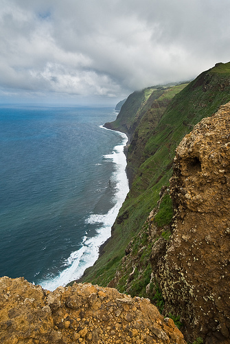
Discover Faja da Ovelha in Portugal
Faja da Ovelha in the region of Madeira with its 1,016 habitants is a place located in Portugal - some 612 mi or ( 985 km ) South-West of Lisbon , the country's capital .
Local time in Faja da Ovelha is now 07:10 AM (Sunday) . The local timezone is named " Atlantic/Madeira " with a UTC offset of 0 hours. Depending on your mobility, these larger cities might be interesting for you: Senhora do Amparo, Seixal, Ribeira da Vaca, Ponta do Sol, and Madalena do Mar. When in this area, you might want to check out Senhora do Amparo . We discovered some clip posted online . Scroll down to see the most favourite one or select the video collection in the navigation. Are you looking for some initial hints on what might be interesting in Faja da Ovelha ? We have collected some references on our attractions page.
Videos
Seiwal in Madeira's Westen - seiwhale - sardinheira
Sehr nah an der Küste trafen wir heute einen Seiwal Quiet near the coast we met a sei whale today Perto da costa encontramos hoje uma baleia sardinheira ..
Paul do Mar and Calheta district Madeira: a better way of life
Paul do Mar is a paradise on Madeira's hottest and sunniest South -West coast. In Calheta district the historic fishing and agricultural village still a centre for fishing and agriculture with a new f ..
Paul do Mar - Faja da Ovelha - Ancient Vereda WALK Madeira
Paul do Mar -- Faja da Ovelha - Ancient Vereda WALK, Madeira This description was written by Paul Abbiati copyright Paul Abbiati, 2011 All rights reserved. Paul is contact for private holiday rental a ..
Madeira: Hotel Colina da Fajã
Das Landhotel mit 9 sehr schönen Zimmern mit herrlichem Ausblick über das Meer und die Hügel wurde 2006 eröffnet. Hier finden Sie neben viel Holz und warmen Farbtönen liebevolle Details und hochwertig ..
Videos provided by Youtube are under the copyright of their owners.
Interesting facts about this location
Caminho Real do Paul do Mar
The Caminho Real do Paul do Mar (Royal Path of Paul do Mar) is a municipal trail in Paul do Mar, in the island of Madeira. It is the first walking trail of the annual Madeira Walking Festival, which takes place in January. The trail starts from the village of Prazeres (535 metres altitude) {{#invoke:Coordinates|coord}}{{#coordinates:32.752483|-17.217014||||||| | |name= }}, and goes down to Paul do Mar Harbour {{#invoke:Coordinates|coord}}{{#coordinates:32.75269|-17.223827||||||| | |name= }}.
Located at 32.75 -17.22 (Lat./Long.); Less than 3 km away
Calheta beach
The Calheta Beach is a beach located near the town Calheta, on the island of Madeira, Portugal. Calheta beach is one of the few sandy beaches of Madeira, with sand imported from North Africa. However, these sand-imports were quite controversial, as the sand was taken from Western Sahara, a Non-Self Governing Territory which has been largely occupied by Morocco since 1975.
Located at 32.72 -17.17 (Lat./Long.); Less than 8 km away
25 Fontes Falls
The 25 Fontes Falls (literally 25 Sources Falls) is a waterfall that is located in Serrado, Ribeira da Janela, near Porto Moniz in the Madeira Islands. This waterfall is 30 feet high forming a variety of drops of water coming down the rocks covered in small plants resulting in a small lagoon. It is involved in the primitive forest Laurisilva of Madeira, in the Macaronesia group os islands in the Atlantic Ocean. The Forest in this location is populated by large quantities of bay trees.
Located at 32.87 -17.17 (Lat./Long.); Less than 12 km away
Tabua, Madeira
Tabua is a parish in the district of Ribeira Brava in the Madeira Islands. The population in 2001 is 1,105, its density is 99.5/km² and the area is 11.1 km². It is located W of Funchal and SE of Madeira. The main industry are agriculture. It is connected with a road linking Calheta and Funchal. The Atlantic Ocean is to the south. The mountains are to the north. The parish of Ponta do Sol borders to its west. Tabua is in a valley setting with a stream running just west of Tabua.
Located at 32.67 -17.08 (Lat./Long.); Less than 19 km away
Ribeira Brava (parish)
Ribeira Brava is the name of a parish in the west-central part of Madeira. It is located in the similarly named district of Ribeira Brava, Madeira It is located SW of Santana, W of Machico, W of Funchal and ESE of Calheta. It is linked with a road linking Calheta and Funchal.
Located at 32.67 -17.06 (Lat./Long.); Less than 20 km away
Pictures
Related Locations
Information of geographic nature is based on public data provided by geonames.org, CIA world facts book, Unesco, DBpedia and wikipedia. Weather is based on NOAA GFS.