-
You are here:
- Homepage »
- Switzerland »
- Ticino » Airolo

Airolo Destination Guide
Discover Airolo in Switzerland
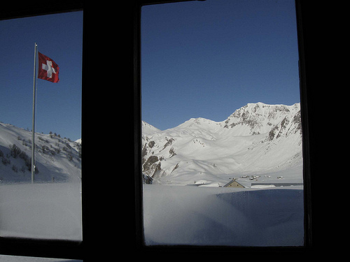
Airolo in the region of Ticino is a town located in Switzerland - some 62 mi or ( 100 km ) South-East of Berne , the country's capital .
Local time in Airolo is now 09:01 PM (Friday) . The local timezone is named " Europe/Zurich " with a UTC offset of 1 hours. Depending on your flexibility, these larger cities might be interesting for you: Zurich, Sornico, San Gottardo, Peccia, and Fusio. When in this area, you might want to check out Zurich . We found some clip posted online . Scroll down to see the most favourite one or select the video collection in the navigation. Are you looking for some initial hints on what might be interesting in Airolo ? We have collected some references on our attractions page.
Videos
Gotthard Tunnel 16.9 km with 6X Speed (Switzerland)
My driving Videos on a Map: schweizerautobahnen.blogspot.com Route in Google Maps: tinyurl.com Driving trough the world second longest road tunnel which is 16.9km long. 6X Speed. Filmed in October 200 ..
Gotthard Tunnel, Switzerland 4X Speed (2010) HD
My driving videos on a map: schweizerautobahnen.blogspot.com Route on Google Maps: tinyurl.com Recorded in March 2010. The Tunnel is 16.9km long. So it is the third longest road tunnel in the world. S ..
Driving St Gotthard Pass #1
Kirsten, Julia & Anna Baumberg driving down the old coach road at St. Gotthard in Switzerland. Listen to Anna scream into her pillow in the backseat of the car. Scared??? Who knows, I guess she was ju ..
Going down San Gottardo
Riding down on the south sides of the Passo di San Gottardo. The old road, set with cobblestones, twists down on the south side on the pass. Riding on my BMW R1150GS. ..
Videos provided by Youtube are under the copyright of their owners.
Interesting facts about this location
Gotthard Tunnel
The Gotthard Tunnel is a 15-kilometre (9 mi) long railway tunnel and forms the summit of the Gotthard Railway in Switzerland. It connects Göschenen with Airolo and was the first tunnel through the Gotthard massif. It is built as one double-track, standard gauge tunnel. The tunnel rises from the northern portal at Göschenen (1106 metres / 3650 ft) and the highest point (1151 metres, or 3800 ft) is reached after approximately 8 kilometres (5 mi).
Located at 46.53 8.60 (Lat./Long.); Less than 0 km away
National Redoubt (Switzerland)
The Swiss National Redoubt (Schweizer Reduit or Réduit suisse) was a defensive plan developed by the Swiss government beginning in the 1880s to respond to foreign invasion. In the opening years of World War II the plan was expanded and refined to deal with a potential German invasion. The German plan, Operation Tannenbaum, was real, but was never carried out.
Located at 46.53 8.59 (Lat./Long.); Less than 1 km away
Lago della Sella
Lago della Sella is a reservoir near St. Gotthard Pass in the canton of Ticino, Switzerland. The gravity dam with a height of 36 m was completed in 1947. The dam was planned and built under control of the Swiss engineer Fritz Gigax.
Located at 46.56 8.60 (Lat./Long.); Less than 4 km away
Swiss Alps
The Swiss Alps are the portion of the Alps mountain range that lies within Switzerland. Because of their central position within the entire Alpine range, they are also known as the Central Alps. The highest summit in the Swiss Alps is Monte Rosa (4,634 metres) near the Swiss-Italian border. The highest mountain which lies entirely on Swiss territory is the Dom (4,545 metres). Other main summits can be found in the list of mountains in Switzerland.
Located at 46.56 8.56 (Lat./Long.); Less than 5 km away
Lago Ritom
Lago Ritom is a small lake in the Piora valley, Ticino, Switzerland. The natural lake is used as a reservoir by the Swiss Federal Railways to generate hydro-electric power for the Gotthard line. The first dam was built in 1918 and, in 1950, its height was increased by 23 m. The lake can be reached by funicular from Piotta 786 m below. The track with a length of 1369 m has a maximum inclination of 87.8%, the highest in Europe. The lake's surface area is 1.49 km² at an elevation of 1850 m.
Located at 46.54 8.69 (Lat./Long.); Less than 6 km away
Pictures

Historical Weather
Related Locations
Information of geographic nature is based on public data provided by geonames.org, CIA world facts book, Unesco, DBpedia and wikipedia. Weather is based on NOAA GFS.