-
You are here:
- Homepage »
- India »
- Himachal Pradesh » Yol

Yol Destination Guide
Delve into Yol in India
Yol in the region of Himachal Pradesh with its 11,314 residents is a city in India - some 251 mi or ( 405 km ) North of New Delhi , the country's capital .
Current time in Yol is now 01:12 AM (Thursday) . The local timezone is named " Asia/Kolkata " with a UTC offset of 5.5 hours. Depending on your travel modalities, these larger destinations might be interesting for you: Sialkot, Rawalpindi, Lahore, Islamabad, and Gujranwala. While being here, make sure to check out Sialkot . We encountered some video on the web . Scroll down to see the most favourite one or select the video collection in the navigation. Are you curious about the possible sightseeing spots and facts in Yol ? We have collected some references on our attractions page.
Videos
Maa Brijeshwari Temple, Kangra, Distt. Kangra, Himachal Pradesh, India
Maa Kangra Wali is a famous temple of northern India. It is one of 52 Shakteepeeths of India (where the parts of body of Sati scattered on earth while Lord Shiva was carrying the chared body of her) ..
Platform2- India by Michelle Webb
a collection of the pictures i took in India-with platform2. 2008-2009 ..
Himalaya Paragliding
Paragliding landing area Bir (india) Himalaya Paragliding ..
Himachali Folk Dance by Students of DAV School Nagrota Suriyan during Bird Counting Week
At Nagrota Suriyan, Forest Department organize Bird Counting Week. Which is an annual event when Birders from different parts of the country visit Pong Dam in Himachal Pradesh State of India. This Dan ..
Videos provided by Youtube are under the copyright of their owners.
Interesting facts about this location
Yol, India
Yol is a cantonment town in Kangra district in the Indian state of Himachal Pradesh.
Located at 32.17 76.20 (Lat./Long.); Less than 0 km away
Kareri Lake
Kareri Lake is a high altitude, shallow, fresh water lake south of the Dhauladhar range approximately 9 km North West of Dharamsala in Kangra district, Himachal Pradesh. Its surface is 2934 metres above the sea level. Kareri lake is best known for being a trekking destination in the Dhauladhars. Snow melting from the Dhauladhar range serves as the source of the lake and a stream, Nyund is the outflow.
Located at 32.20 76.16 (Lat./Long.); Less than 5 km away
Gaggal Airport
Gaggal Airport, alternatively known as Kangra Airport or Dharamsala-Kangra Airport, is an airport located in Gaggal near Kangra in the Indian state of Himachal Pradesh, 14 Kilometres South-West of Dharamshala.
Located at 32.17 76.26 (Lat./Long.); Less than 6 km away
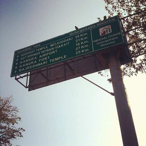
Kangra Fort
The Kangra Fort, is located 20 kilometers from the town of Dharamsala on the outskirts of the town of Kangra, India. The fort was first mentioned in Alexander the Great's war records, referring to the 4th century BC.
Located at 32.10 76.27 (Lat./Long.); Less than 10 km away
Kangra, Himachal Pradesh
Kangra is a city and a municipal council in Kangra district in the Indian state of Himachal Pradesh. Historically it was known as Nagarkot.
Located at 32.10 76.27 (Lat./Long.); Less than 10 km away
Pictures
Historical Weather
Related Locations
Information of geographic nature is based on public data provided by geonames.org, CIA world facts book, Unesco, DBpedia and wikipedia. Weather is based on NOAA GFS.