
Explore San Pablo Ixquitlan in Mexico
San Pablo Ixquitlan in the region of México is a town in Mexico - some 27 mi or ( 44 km ) North-East of Mexico City , the country's capital city .
Current time in San Pablo Ixquitlan is now 11:30 PM (Sunday) . The local timezone is named " America/Mexico City " with a UTC offset of -6 hours. Depending on the availability of means of transportation, these more prominent locations might be interesting for you: Toluca, Tizayuca, Tepetlaoxtoc de Hidalgo, Santa Cruz Tecamac, and Puebla. Since you are here already, make sure to check out Toluca . We saw some video on the web . Scroll down to see the most favourite one or select the video collection in the navigation. Where to go and what to see in San Pablo Ixquitlan ? We have collected some references on our attractions page.
Videos
Teotihuacan - The City of the Gods
Pyramid of the Sun ..
Episode 15: Teotihucan
A tour of the Aztec city of Teotihucan. ..
Ellen Degeneres conquers Mexico
Aspiring field agent Gwen McCrory helping Ellen unite the world with laughter and dancing. ..
Teotihuacán, Mexico (Juan Carlos Gachet)
Claudia, Fernando Vazquez y Juan Carlos Gachet se aventuraron a esta fantastica zona arqueologica de los Aztecas de Teotihuacan en pleno corazon de Mexico. Las ruinas de Teotihuacán están entre el más ..
Videos provided by Youtube are under the copyright of their owners.
Interesting facts about this location
Pyramid of the Moon
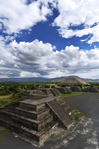
The Pyramid of the Moon is the second largest pyramid in Teotihuacan, Mexico after the Pyramid of the Sun. It is located in the western part of Teotihuacan and mimics the contours of the mountain Cerro Gordo, just north of the site. Some have called it Tenan, which in Nahuatl, means "mother or protective stone. " The Pyramid of the Moon covers a structure older than the Pyramid of the Sun which existed prior to 200 AD.
Located at 19.70 -98.84 (Lat./Long.); Less than 1 km away
Teotihuacan
Teotihuacan, also written Teotihuacán, is an enormous archaeological site in the Basin of Mexico, 30 miles northeast of Mexico City, containing some of the largest Mesoamerican pyramids built in the pre-Columbian Americas. The name means "where man met the gods. " Apart from the pyramids, Teotihuacan is also known for its large residential complexes, the Avenue of the Dead, and numerous colorful, well-preserved murals.
Located at 19.69 -98.84 (Lat./Long.); Less than 2 km away
Pyramid of the Sun
The Pyramid of the Sun is the largest building in Teotihuacan and one of the largest in Mesoamerica. Found along the Avenue of the Dead, in between the Pyramid of the Moon and the Ciudadela, and in the shadow of the massive mountain Cerro Gordo, the pyramid is part of a large complex in the heart of the city.
Located at 19.69 -98.84 (Lat./Long.); Less than 2 km away
Temple of the Feathered Serpent, Teotihuacan
The Temple of the Feathered Serpent is the modern-day name for the third largest pyramid at Teotihuacan, a pre-Columbian site in central Mexico. This structure is notable partly due to the discovery in the 1980s of more than a hundred possibly-sacrificial victims found buried beneath the structure. The burials, like the structure, are dated to some time between 150 and 200 CE. The pyramid takes its name from representations of the Mesoamerican "feathered serpent" deity which covered its sides.
Located at 19.68 -98.85 (Lat./Long.); Less than 3 km away
Otumba de Gómez Farías
Otumba or Otumba de Gómez Farías is a town and municipality located in the northeast of the State of Mexico, just northeast of Mexico City. Historically, this area is best known as the site of the Battle of Otumba and as an important crossroads during the colonial period where incoming viceroys ceremoniously were handed power by their predecessors. Today, it is a rural municipality undergoing changes as urbanization arrives here from the Mexico City area.
Located at 19.70 -98.75 (Lat./Long.); Less than 9 km away
Pictures

Related Locations
Information of geographic nature is based on public data provided by geonames.org, CIA world facts book, Unesco, DBpedia and wikipedia. Weather is based on NOAA GFS.