-
You are here:
- Homepage »
- United Kingdom »
- England » Seaton Delaval

Seaton Delaval Destination Guide
Delve into Seaton Delaval in United Kingdom
Seaton Delaval in the region of England with its 7,219 residents is located in United Kingdom - some 253 mi or ( 407 km ) North of London , the country's capital .
Local time in Seaton Delaval is now 04:42 PM (Tuesday) . The local timezone is named " Europe/London " with a UTC offset of 0 hours. Depending on your mobility, these larger destinations might be interesting for you: York, Wallsend, Sunderland, South Shields, and Sheffield. While being here, you might want to check out York . We discovered some clip posted online . Scroll down to see the most favourite one or select the video collection in the navigation. Are you curious about the possible sightseeing spots and facts in Seaton Delaval ? We have collected some references on our attractions page.
Videos
Plant Biology (Photosynthesis song) - The chloroplast and the LDR
"Plant Biology" - Here's the final music video for our A2 Biology presentation. We went through some hiccoughs actually producing it - video quality is TERRIBLE because the footage wasn't transferred ..
Newcastle Super Storm and floods on 28 June 2012
Super Storm arrives in Northumberland. This video shows the initial darkening of the sky as the storm approaches, then part of a 20 minute car journey - the storm itself continued for a full 2 hours a ..
Animal Crossing money cheat
Heres a video for all you people new to Animal Crossing wild world or lets go to the city/ city folk. This will help you get more bells =] music: system of a down - needles ..
Sailing Trésor to Blyth
Sailing our Beneteau oceanis 343 to Blyth Uk and back again on a very nice evening and afternoon ..
Videos provided by Youtube are under the copyright of their owners.
Interesting facts about this location
Seaton Valley Urban District
Seaton Valley was an urban district in Northumberland, England, from 1935 to 1974, when it was split between the districts of North Tyneside and Blyth Valley. It was created by a County Review Order in 1935 from various urban districts near the North Sea coast, particularly Cramlington, most of Earsdon, Seaton Delaval, and Seghill.
Located at 55.08 -1.53 (Lat./Long.); Less than 1 km away
Hartley Colliery Disaster
The Hartley Colliery Disaster (also known as the Hartley Pit Disaster) was a disastrous mining accident in Northumberland, England in 1862 in which 220 lives were lost. The disaster arose from a combination of the mine having a single shaft; and the fracture of a metal steam engine beam, blocking the shaft.
Located at 55.09 -1.53 (Lat./Long.); Less than 2 km away
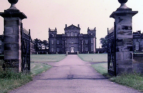
Seaton Delaval Hall
Seaton Delaval Hall is a Grade I listed country house in Northumberland, England. It is near the coast just north of Newcastle upon Tyne. Located between Seaton Sluice and Seaton Delaval, it was designed by Sir John Vanbrugh in 1718 for Admiral George Delaval and is now owned by the National Trust. Since completion of the house in 1728, it has had an unfortunate history.
Located at 55.08 -1.50 (Lat./Long.); Less than 2 km away
A189 road
The A189 is a road in North East England, linking Gateshead to southeast Northumberland. The section within southeast Northumberland is also known as the Spine Road; and West-Central Route is used to describe its route around Newcastle City Centre. The A189 crosses the River Tyne by means of the New Redheugh Bridge, one of several bridges across the Tyne in the centre of the NewcastleGateshead conurbation.
Located at 55.08 -1.57 (Lat./Long.); Less than 3 km away
Wellfield Middle School
Wellfield Middle School is in Whitley Bay, North Tyneside serving the areas of Wellfield, Earsdon and West Monkseaton. It currently has about 230 pupils on its roll from the ages of 9 up to 13.
Located at 55.04 -1.49 (Lat./Long.); Less than 4 km away
Pictures
Related Locations
Information of geographic nature is based on public data provided by geonames.org, CIA world facts book, Unesco, DBpedia and wikipedia. Weather is based on NOAA GFS.